Dholavira: A slice of Harappa in Gujarat
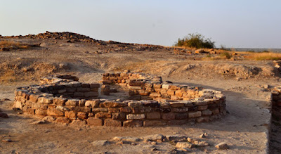
Remians of circular hutments in Dholavira.
As he stood on the ruins of the lost city of Dholavira in Gujarat, Jaimal beamed with a sense of nostalgia and pride that comes from his association with the archaeological digs here since the late 80’s, when, as a young boy, he volunteered to work on the site with an officer of the Archaeological Survey of India (ASI). In doing so, Jaimal found a passion he believes will last a lifetime – being the bridge of communication between ASI officials and local labour, thus helping the world know the story of Dholavira.
It was Jaimal’s intimate knowledge of this historic site that made my visit to Dholavira so unique.
Large water tank to the north of the city. Dholavira had a network of tanks around the city to store rain water for use by the city's residents.
The magnificent ruins of Dholavira throw light on Harappan culture and reveal the planning and architecture that maps the rise and fall of this magnificent civilisation. Located on an island surrounded by the Greater Rann of Kutch, the remains of Dholavira are an example of the marvels of hydro-engineering mastered by the ancient.
The city, it seems, was fairly important during the Indus Valley days as excavations have found evidence of seven layers, indicating as many settlements over a period of 1500 years. Despite its harsh location, the city was an important trading point and the builders of Dholavira devised technologically sound water-harvesting systems to cater to the needs of a large population.
Two monolithic pillar stand at the place which led to the citadel part of the city.
There is evidence of rainwater harvesting systems, a network of tanks and ponds that supply water and even a sewage system much better than in many of our modern cities. The ruins at Dholavira is divided into three zones: the citadel (where the rulers or high officials stayed), the middle city and the lower city. Archaeologists have identified seven different stages in the city design and different artefacts found around the digs.
Strangely enough, civilisation petered out after the seventh stage and the site was never occupied again. Some historians blame it on the lack of potable water, as the salt pans of the Rann of Kutch may have rendered the water too brackish for consumption.
The remains of large pillars marking the entrance to the city. The pillars have a smooth finish, indicating use of tools to give this finishing to the pillars.
One very interesting aspect here is an inscription with 10 large signs, which is probably one of the first evidence of a written language. Historians are yet to crack the linguistic code in the inscription. A small museum located at the entrance of the site houses artefacts that give you an idea of how people lived during the Indus Valley Civilisation. You can see the progression from mud and basic tools to iron and copper implements, gold jewellery and cooking vessels.
Getting to Dholavira is not easy. It’s a six-hour drive from Ahmedabad. There is a basic Gujarat Tourism guest house to spend a night there, but is best avoided. So if you leave early morning from Ahmedabad, plan to reach Dholavira by early afternoon, spend a few hours at the ruins and head out to Bhuj for the Greater Rann of Kutch.
Although Dholavira is a little out of the way from other tourist destinations in Gujarat, it’s something that those with curious minds and a sense of adventure shouldn’t miss.


Comments
Post a Comment